Abstract
In this paper, we present the Media Portrait of the Liberties (MPL), a hands-on investigation of a new, digitally mediated form of narrative experience that makes extensive use of mobile computing technology. An urban neighborhood is a physical embodiment of a community’s memories and history. Location-aware mobile narrative systems have significant potential when applied to urban spaces, especially spaces in disadvantaged areas. Such systems can empower communities by providing a forum in which they can express, recall, and celebrate the culture and history of their neighborhood, supporting perception of it as a cultural place as opposed to simply a space. Kluitenberg defines public domain as a social and cultural space characterized by commonly shared ideas and memories, as well as the physical manifestations that embody them. Following Kluitenberg’s definition, the MPL renders the public domain as a tangible media artefact. The MPL is an evolving collection of historically inspired video stories adapted from written accounts of life in the deprived but culturally cohesive inner city area of Dublin, Ireland, known as "the Liberties." The stories are delivered to the audience on location-aware PDAs, and each story can only be viewed when an audience member is situated in the physical place where the story is set. The objective of the MPL is to provide viewers with a nuanced and evocative sense of place as they walk the streets of this striking neighborhood. The MPL's author-centric approach to community stories is designed to function as a story-catalyst for the local community. The approach offers them a starting point and the inspiration to take ownership of the project and continue to develop its collection by contributing as authors to an ongoing story database rendering a grass-roots history of the area. This paper describes the content capture, design, and implementation of the project, but focuses primarily on the results of a subjective user study conducted to gauge reactions to this novel media format. We conclude the paper by discussing the results of this study and speculating on future directions for this work.
Introduction
Why distribute a community's stories around the streets of its neighborhood? The answers to this question are numerous and cover broad intellectual, emotional, and sociological ground. The fact that stories are fundamentally valuable is beyond reproach. It is undeniable that stories form a universal mechanism for sharing information about ourselves and others, for imparting lessons, and for more frivolous purposes: to inspire and entertain. More seriously, stories and narratives also serve an important social function as a stimulus to discussion and debate. Furthermore, stories connect us to distant places and times and form a significant portion of not only present-day culture, but also the legacy that we will pass on to future generations. The important role that stories play in our lives has had the effect that new technologies are rapidly adopted, or even developed specifically, for the purpose of storytelling. Cinema is probably the most prominent example of this, but computer games, some of which now contain relatively sophisticated narratives, are an emerging contender for this title. In the Western world, it is easily arguable that the popularity of screen-based media has surpassed that of live performance (in the form of theater or oral storytelling). As a result, the vast majority of stories are now told away from the grungy physicality of the real world, and in familiar, sterile, two-dimensional landscapes composed of darkened rooms and glowing screens.
We believe, however, that that we are on the cusp of a technological shift that has the potential to alter our storytelling practices once again. Advances in the areas of mobile and ubiquitous computing, location-tracking systems, and wireless networking enable us to push stories beyond the screen and back into real space. By co-locating places and stories, we can create a rich synergetic experience of place, a complimentary merging of narrative and environment. By allowing our audience to see, smell, feel and hear a place, while simultaneously experiencing its stories and history, we can paint a rich and nuanced picture of this place. Samuel Smiles defines place as something "we rather feel than understand: an indistinct region of awareness" [1], and it is this abstract concept that we are interested in conveying. In the Media Portrait of the Liberties (MPL) project, we combine mobile wireless technology and the framework of locative media to construct a novel system that allows its audience to vividly experience a community's public spaces through the stories, anecdotes and memories of its local residents. We believe this represents a provocative pairing of new technology and the digital arts.
The Media Portrait of the Liberties (MPL) is a modular collection of anecdotal stories drawn from a disadvantaged Dublin inner city neighborhood called the Liberties. Characters and themes reported by our sources in the community provide a natural hyperlinked structure for these non-linear narrative segments. The narratives are displayed as short video clips on a location-aware handheld computer.
The story expressed in each video clip was taken from historical, literary, and word-of-mouth accounts of life in this area in the past. Each story also references specific streets, buildings, or courtyards in the Liberties and is only available for viewing when a user is in or close to these objects. For instance, a story describing the historical grandeur of a building can only be viewed when a user is standing next to its present-day ruins. Stories about local characters or family dramas can be watched only in the streets where the events described actually took place. Our investigations indicate that presenting this rich narrative content set in a particular place to users situated and physically immersed in that same place provides a vivid and evocative experience that encapsulates something of the "sense of place" described by Smiles.
Given its substantial scope, the development of MPL encompassed a number of diverse activities. A significant effort was involved in the collection, scripting, shooting and editing of the video clips that form its content. Beyond these standard production tasks, we also had to situate each piece of media meaningfully in the physical environment. Due to the fact that the media would be experienced in a distributed and fragmented fashion, we developed plots around multiple themes and characters that richly intersected with one another. To represent these thematic links, we created a simple information architecture that allowed users of the system to follow multiple paths through the library of clips, experiencing them in an order dictated not only by their physical path through the city, but also by the topics that caught their interest. On the technical side, we constructed location-aware display software for this content and, more challengingly, attempted to design an interface to seamlessly access the stories' complexity. Finally, we performed an extensive subjective user study of the system to gauge the reactions it provoked in its audience.
The extensive user study captured the reaction of a broad spectrum of audience members: local residents re-evaluated and reflected on their history while non-residents and tourists explored the area's past and developed interest and empathy towards a neighborhood and a community that is otherwise relatively inaccessible. The MPL project, through its author-, centered approach, enhances community life and local residents' perception of their neighborhood. It inspires locals to recall and share their personal anecdotes and stimulates tourists' and casual visitors' awareness and understanding of this disadvantaged area. The study of the local audience's reactions has highlighted the benefits and the future possibilities for such a story approach. In experiencing the MPL, local community members discovered new stories about their neighborhood and remembered anecdotes that relate the history of the area to events in their personal lives. The evaluation process often stimulated dialogue between community members and passers-by, demonstrating the MPL's function as a catalyst for enhancing communication. Furthermore, local residents were inspired to contribute to the story database with their own memories and to learn how to use technology to experience and create stories, eventually building a grass-roots historical and social database of the neighbourhood.
The remainder of this paper describes the steps and the lifecycle of this project from inception to completion, and concludes by distilling our analysis of the data collected during the user study to provide an initial set of design heuristics for future mobile location-aware narratives.
Methodology for Story Creation
Researching and Reconstructing the Story
The MPL content is a collection of stories based on the life of a community of people living in the same neighborhood. Factually based stories appeal to us because they are directly connected with what we perceive to be "real" events and history. Such stories can provide us with inspiration for our own lives, prompting us to recollect anecdotes and trigger personal memories. Like a spider web, real stories lead into each other; they connect characters and themes providing a natural hyperlinked structure that can be used as the basis for an interactive modular narrative.
While researching the content for the MPL, we made contact with members of the Liberties community, who contributed content to the project with enthusiasm: for example, local community member Charlie Hammond told us stories about the Poddle, a river that runs underground through the Liberties and was the second water supply for the city after the main river Liffey. The Poddle is the reason why breweries and distilleries, laundries, and weavers of silk and poplin flourished in the area, producing a labor-intensive and thriving industry. Local writer Mairin Johnston took us on a tour of the area and told us stories about her family moving into the neighborhood from Galway during the famine era. We interpreted the enthusiasm and participation of local people as a genuine sign of the desire of the community itself to share their sense of history through the project. Charlie commented in one of our conversations: "Social history is rich in this area. I believe it is important for this community to understand their own neighborhood." To start the content production, an initial set of twenty short stories were selected from Johnston's book "Around the Banks of Pimlico" [2], ranging from Johnston's family stories to socio-historical anecdotes about the area.
Figure 1. Set for the filming of "Mickey Murphy's Yard" story.
Photo: Rob Bourke.  Production Phase Production Phase
The MPL stories were scripted and produced through a variety of methods according to their different characteristics. The stories ranged from ghost stories and descriptions of architectural changes in the area to individual portraits of local characters. In creating the audiovisual media segments, we used a mix of video, animation, and photographic media and a narrating voice that related the anecdotes in the first person (which coincides with thefirst-person narrative found in Johnston's book).
Film sets were staged around the Liberties area. Stories were re-enacted using costumes and settings inspired by the descriptions in Johnston's book. For example, the enactment of a traditional music session that took place every Sunday in Mickey Murphy's Yard during the 1940s brought together researchers and the film crew with local community members and actors. [Fig. 1] This episode created a vibrant atmosphere and connection between past and present, real time storytelling, and reinterpretation of the local past.
Irish traditional musicians played in the courtyard of the Pimlico cottages for an afternoon. Local people came along and engaged in the action, participating as local characters in the filming. The session itself was also an opportunity to chat informally with locals about the project and verify their enthusiasm for providing new content to the story collection, reviving memories, anecdotes, and a sense of pride of being from the Liberties area. A different kind of story, referencing buildings that do not exist anymore or particular events too complex to re-enact, was produced by using some of the material collected during the research, such as old photographs and watercolor sketches produced during the storyboarding process. Segments featuring another type of story, referencing ghosts and supernatural events, were produced through blue screening and digital effects. The varied methodology added expressivity and freshness to the media pieces and highlighted some ideas for how to develop a framework under which to guide the community members in the feedback collection phase, when they will be able to provide and produce their own stories to add to the collection.
The MPL Interface
In parallel with the production of the MPL content we also designed the interface through which we could deliver the stories to their audience. As a hardware platform we selected an iPAQ handheld computer, equipped with a GPS card to provide location awareness, and a large SD memory card on which to store the video material. The iPAQ is easily programmable and comfortably capable of displaying the rich multimedia content used in the MPL, and GPS is a standard technology for location-awareness. The choice to use SD storage to house the content, rather than have it delivered over a wireless network, reflects the infancy of these technologies in Ireland at the time. As we were primarily interested in the user experience of the project, we opted for the simplicity and reliability of local storage.
The MPL interface takes the form of an interactive map displayed full screen on the handheld device. To help users locate the story content on the map and orient themselves in the real space and in relation to the stories, we designed a series of graphical navigational aids as part of the interface. [Fig. 2] The navigational aids can all be switched on or off independently. The more aids are activated, the more the user is guided through the Liberties tour. With fewer aids chosen, the experience becomes more akin to a free exploration of the area where people can stumble upon story material unexpectedly. We describe the design and functionality of these interface elements in more detail below.
Map: The map is hand-drawn, but neatly labelled with street names. The minimalist hand-drawn style serves to distance the piece from other map-based interfaces (e.g., tourist guidebook applications or route finding software), while the street names are included to ensure the map remains a meaningful navigational aid. To present a reasonable level of detail, the map is larger than the screen of the handheld device, but can be scrolled simply by dragging the iPAQ stylus across the screen. Although this differs from the display paradigm found in much location-aware software (where the on-screen map is always centered on the user's current position), we feel it is appropriate for our project, which focuses more on whimsical exploration than efficient goal-driven navigation. By letting users scroll the map freely, we let them search the map for stories beyond their immediate vicinity.
Story markers: These indicate the position of each story on the map. They take the form of small high-contrast green dots. They are designed to stand out from, but not to obscure, the map.
Story icons: The story icons are the interface through which the audience activates video clips, and through which we display the links and inter-relationships between the stories. They take the form of shrunken, representative frames extracted from the stories. They appear on the map under one of two conditions: either the user's position coincides with the story's location or the story is related to the last story viewed. In this second case, the story icon is displayed semi-transparently. Each icon also features additional information in the form of small markers along its rightmost edge. Three different markers are being used. A triangular play symbol indicates that a story is currently available for viewing. Selecting an icon marked in this way causes the video clip with which it is associated to play full screen, returning the user to the map upon completion. Video clips that have already been viewed are further marked with a "tick symbol" to indicate the "viewed" status. In addition to being semi-transparent, the clips related to the most recently viewed one, but not currently available for viewing because they are situated in an area of the map away from the user's current position, are marked with an icon showing a series of footsteps. If the user moves to the map location occupied by such an icon, its state, and graphical representation, changes to that of a currently playable icon. The intention is to give users the choice to follow particular themes, lending them a sense of control and providing additional structure for the piece.
Radar: The radar provides an overview of the map. It takes the form of a transparent grey area in the bottom right of the screen, which represents the total map area. A darker rectangle within it indicates the portion of the map currently shown on the screen. This adjusts automatically as the user scrolls the map. A small red dot indicates the user's current position, as calculated from the GPS readings. This radar view shares many similarities with those views designed for use in shared editor CSCW systems.
User position indicator: This indicator takes the form of a small semitransparent circle, which simply shows the user's current (GPS-derived) position on the map. If a user selects the position indicator using the stylus, a screen displaying all the stories previously viewed is displayed in the form of a list of story icons. Clicking on an icon displays the story once again, irrespective of the user's current position.
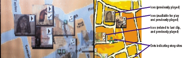
Figure 2. Graphical interface screenshots showing the map, the radar, the green dots, the story icons, and their related symbols.
User Study Discussion
The process of storytelling always involves a story, a narrator, a medium, and an audience. To complete the project, a user study was designed to capture the audience response to the experience. We defined three broad audience samples: media experts, community members, and non-residents. The media experts were people with experience in digital media technologies from artistic, technical and / or educational angles. Within the community sample were people who were born and lived in the area, as well as people who moved to the Liberties at a later stage of their lives and considered themselves members of the community. For the non-residents category, we sampled people from outside the Liberties neighborhood, ranging from Dubliners to native Irish people and foreigners, some of which were tourists, others foreign nationals living in Dublin. The broad sampling was intended to capture a very wide variety of audience members and identify parameters for more focused future investigations. The methodology for evaluation involved observation by shadowing the participants in their tour of the area, recording their comments and engaging in a semi-structured interview at the end of the experience. [3] We studied seven cases for each audience category. Their comments were recorded through a wearable audio recorder as they were touring the Liberties neighborhood with the iPAQ in search of stories. Three users from each group experienced the Liberties project on their own while the other four toured in pairs resulting in a total of four tours per category. [Fig. 3] This method was used to investigate what kind of exchanges among audience members were prompted on location. As the people were walking around the streets experiencing the stories, we observed them at a distance, trying not to influence their choices, recording their trail through the Liberties and taking notes about their behavior. At the end of the tour, the audience members were assembled for a focused conversation about their experience with the MPL.
Analysis of the results showed a high level of interest in and engagement with the project by all participants. Audience members from different user groups demonstrated different foci. The next section describes the issues brought up by each audience group and the three main categories that emerged from the collected data.
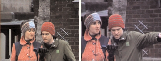
Figure 3. People experiencing the MPL as a pair.
Community Reaction
Community members were selected from the "Living Heritage" class organized by the local community centrr of Saint Nicolas of Myra on Carman Street, in the heart of the Liberties. The experience of following local people around the Liberties was very different experience from observing audience members who were not residents in the neighborhood. People on the streets had a very friendly attitude towards the users that they recognized as community members. Conversations with passers-by would often start spontaneously, with topics ranging from questions about what they were doing to updates on local news and events happening in the neighborhood. The Liberties is a disadvantaged inner city area, and it was clear that both the authors and audience members who are not native to the area were not able to relax as much, even if they still enjoyed the overall experience.
Some of the community-sampled participants were born in the area. Their ancestors were rooted in the Liberties for at least three generations. All of them remembered the visits to the dispensary officer in South Earl Street Health Centre, a central character in one of the clips. People remembered him and told us how he was still performing his job with the same rude manners portrayed in the story appearing in the MPL and how everybody hated going up to him to collect their prescriptions. Finding a character the audience members could relate to in real life released a sense of confidence and achievement in the participants and pulled them right into the story, connecting the anecdote and the history of the place to their actual lives. Another evocative story on location was embedded in Braithwaite Street: two audience members' parents used to live on that street and knew the family of the man portrayed in the anecdote. At one time, he was a familiar face in the Liberties, walking the streets selling coal from a horse-drawn cart. Two participants, Liz and Meriel told us that when they were children they used to play in the shed where he stored the coal, even though it was dirty and full of rats. Other users also recalled him shouting "Coal" as his horse and cart criss-crossed the Liberties.
When returning to the San Nicolas of Myra community center for the focused discussions, members of the "Living Heritage" class would spontaneously join the conversation. Stories were volunteered about the poor conditions of the area in the past, and how men used to run to the pubs and bars as soon as they cashed in their salary; how women were not allowed to enter the pubs until recently and used to have to ask a man they trusted to go to retrieve some of their husbands' money before it was all spent on drinks; how people from the area still know today which houses originally belonged to the Guinness workers and which to the Jacobs factory workers, despite the fact that the Jacobs biscuit factory is not located in the area anymore and Guinness now employs very few Liberties residents. These sessions clearly indicated the interest of the community in participating and contributing to MPL expanding the story database with old and new anecdotes about their neighborhood.
Non-Residents Reaction
The non-residents showed a variety of reactions to the MPL. A general comment was that the experience was interesting because it let them roam and explore an area that they would have never have got to know otherwise. The Dublin Liberties is a famous inner city neighborhood, well known for its disadvantaged conditions, and despite its great history, people would not spontaneously venture into this area. The comments showed the potential of the MPL for encouraging an alternative type of tourism, geared towards areas not marked by the usual tourist trails. Many enjoyed listening to stories that would tell them about the origins, the old architectural structures, and the socio-historical conditions of the Liberties; stories about the Courthouse of the Liberties; or the Brabazon family, descended from the Lords of the area. Some of the non-resident audience members expressed a desire to know specific dates and facts about striking local monuments such as the statue of the Jesus on Gray Street. John Gallagher, a local community member, was present on location when Oscar, a Cuban currently living in Dublin, made this comment and was able to answer the question immediately. This example and other similar episodes highlight how the system not only prompts memories and anecdotes about the neighborhood in local people but can also stimulate a dialogue between locals and visitors as they walk the streets of the neighborhood with the handheld device.
Some non-residents did not connect to local story characters, such as Honora and her family who moved around the Liberties from house to house and job to job. They found those stories too disjointed to be able to synthesize them as a whole. We attribute such reactions in part to the fragmented nature of the narrative, but have identified a number of other possible reasons for this experience. For example, not being from the area and therefore not being able to connect the story fragments to similar stories that might have occurred in a relative's life was also an important factor. The lack of a cultural reference frame may have diminished non-residents' interest in and capability to relate to these kinds of story fragments. A few users originally from other areas of Dublin realized that similar stories existed even in their own neighborhood. This cultural reference would spark interest in the adventures of the Johnston family struggling through economic highs and lows, moving premises around the neighborhood every few years, and constantly dealing with the everyday problems of health and accommodation.
Media Experts Reaction
The respective skills and knowledge of the media experts led them to focus on different aspects of the MPL. Media experts with technical background focused their attention on the GPS performance and software capabilities. Some multimedia experts found the user interface and the iPAQ platform distracting from the story experience (even if it was simple enough to use easily). One reason for their distraction was the fact that they were engrossed in understanding the interface issues and unfamiliar with the Liberties neighborhood, so that the navigation of the real space was a demanding task. Rainer, a German writer with multimedia experience, felt the stories were too fragmented to form a coherent narrative structure, based on his more traditional understanding of a narrative point of view. He reported that the characters lacked motivations and psychological depth. Users more familiar with the fragmented nature of most interactive narratives found the fragments pleasing and reported that the relationships between the fragments were engaging and motivated them to seek related story fragments. We can infer from these comments that the audience engagement and relative success of the non-linear interactive aspect of the stories is highly dependent on the participants' background and disposition towards alternative story structures, compared to more traditional forms.
Some users observed that the link between a story and a specific location was not always obvious. Audience members from other categories also reported this observation, but the media experts were able to articulate a more complex analysis and to suggest solutions to this phenomenon. During the observation we noticed that due to the GPS resolution (approximately 10-15 meters), the audience members were not always situated in the exact physical location when a story become available to them. Also, their position in relation to the space varied according to which side of the street they walked on, which way their gaze was directed, and whether they stopped to view story fragments, or kept walking. Furthermore, the audiovisual media fragments did not always provide precise pointers as to their setting.
Discussion and Findings
In our study we targeted three main aspects of the work: the story design and content; the interface between the stories and the place; and finally, the audience feel for the technology. Mirroring this focus, we have grouped our data in three main categories of comments: observations regarding the stories, the interface, and the technology used.
Story Design
The modular structure of the story collection evoked different responses. Some users were open to challenging their own notion of traditional narrative structure and enjoyed the fragmented nature of the narrative; they found it engaging and were motivated to find more story parts to complete the picture. They often compared the experience to puzzle solving or a treasure hunt, seeing their role as that of explorers or detectives in search of clues. Other users found the fragmented nature of the narrative confusing and frustrating. These users expressed a desire to be able to experience the fragments in a more linear, traditional way. A timeline was proposed, in order to facilitate the experience of the stories in chronological order. There were also comments about character development. The main suggestion for strengthening the characters was to have them introduce themselves and contextualize their position in the Johnston family, i.e., informing the audience in which relationship they stand to the narrator. In fact, this was the approach that was actually implemented in the project. The narrator, who adopts the point of view of Mairin Johnston, the last surviving member of the Johnston family, talks in the first person and specifies her relationship to each of the characters. For example, "Honora, my great, great, grandmother used to live in Pimlico…" Based on the users comments, this technique seemed to be insufficient for describing the complex web of the Johnston ancestors who feature in the story fragments. Furthermore, the relationships among stories were not obvious to everybody. Suggestions to strengthen these links ranged from displaying trails on the map in order to highlight continuity between stories' themes, to using the narrator for explicitly making connections with other stories and passing on suggestions as to where the audience should go next to collect related stories. Additionally, as briefly mentioned in the media expert section, people from outside the neighborhood did not always find the story obviously linked to its relative location. One suggestion was to start each video clip with an image of the location to which the story relates, instead of having the location visualized somewhere in the middle of the clip, according to the demands of the story being told. Another one was to use the narration to direct the audience's gaze in the appropriate direction. For instance, stories could commence in the following style: "Can you see the red brick building opposite South Earl Street no 8? That used to be the local Health Centre." By explicitly naming and describing the important locations, audiences would familiarize themselves with the setting before the beginning of the story, without missing out on the visuals or feeling confused about what they should be looking at.
The stories were portrayed in audiovisual format. People generally enjoyed the visuals and the mixed media style composed of re-enacted stories, old pictures showing the area as it used to be, and watercolor sketches extracted from the storyboard. [Fig. 4]
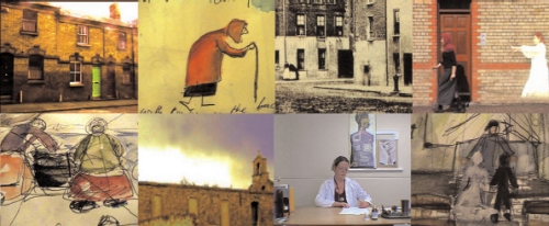
Figure 4. Frames from two different stories’ video-clips.
People often commented that they had to look at the video twice. The richness of the media combined with looking around the real place proved to be overwhelming because they had to make contact with the surrounding architecture and simultaneously identify the location to which the story related. However, only one person reported that he would have preferred to experience the MPL just as audio narration. This was a positive and encouraging result in respect to our choice of portraying the anecdotes in audio-visual format since the majority of similar locative media projects do not include video material and we had chosen to challenge the audio-only format, spending a great amount of time and effort in producing the stories visually.
The audience also showed a positive reaction to the different types of voices cast for the narration. Different users connected with one narrator more than another, to the point of really not enjoying some stories because of the narrator's voice or accent. These comments highlighted the importance of attention to the artistic quality of the work in parallel with the interaction and interface design choices.
Figure 5. Handheld device in one of the Liberties story locations. 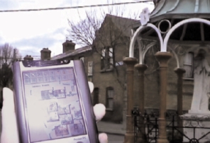 Interface Design Interface Design
The interface was generally reported to be easy to understand and use. [Fig. 5] The map had to be manually scrolled, which some users found distracting or confusing. This was especially the case when the user position was not visible on the map shown on the screen. One suggestions was to automatically re-center the map around the user. However, most of the users appreciated the manual scrolling, because it allowed them to explore the whole area and look for related stories that were not located in the map portion shown on the screen. The navigational aids, such as the radar view and cursor indicating the users' position on the map according to the GPS readings, were also reported as useful and easy to understand. The markers that indicated the presence of the stories (the green dots indicating story presence in the area and icons indicating stories video clips) prompted a range of responses. A frequent comment was that the dots showing story locations on the map could have held more information. For example, dots of different colors could indicate whether stories had already been viewed, as many people were unable to remember which stories they had already seen, even when they returned to a previously visited location. The icons that appear on the map to point out story availability were often considered as cluttering rather than useful information, limiting the visibility of the map and being of little descriptive value. The majority of the users commented that they would have liked to be able to switch off the icons in order to be able to see the map more clearly. However, one user reported that he really enjoyed the icons' richness, and found them colorful and pleasant. Some users suggested that pre-tested trails could be added to the map in order to encourage thematic tours or allow for following a specific character. Also proposed were time-based trails, so that people could choose a path according to the amount of time available to them.
The Technology
The technology used for the MPL (GPS-enabled iPAQ and the Pimlico custom-made software platform) proved to be both simple to interact with and reliable. This was important since a significant portion of our target audience had limited experience with computer technology and was expected to be reluctant to engage with the project for that reason. The simple interface we developed played a considerable part in the project's success. The choice of an iPAQ for the experience was a good one. As a miniature portable cinema screen, the iPAQ delivers good quality audiovisual media that facilitated engagement with both the audio narration and the visual interpretation of the story.
The fact that locations were not always immediately recognizable can only be partly attributed to the resolution of the GPS technology. Specific filming and narrative techniques (as explained in the section on the story design) could be combined with technologies offering more accurate localization, such as Bluetooth beacons or RFID tags, to ensure that stories could only be retrieved in the exact locations to which they related.
The smoothness of the technology performance on the hardware and software side made it easy for most audience members to focus on the stories. Understandably, people unfamiliar with the area had more difficulties. Rainer and Sara, a German and an American who had been living in Dublin for about six months, found it hard to navigate around the new area, simultaneously relating to the stories and the real locations, and coordinating where they had already been with where they wanted to go next.
It is interesting to note that both media experts and non-residents at times would become engrossed in or distracted by the system, while the Liberties community members focused on the content more easily despite being among the less computer-literate users; they paid little attention to the technology, using it simply as a tool for retrieving the stories.
Conclusions and Future Work
By means of this first broad user study we established that the project succeeded in enhancing a neighborhood space by making stories about the area available to the public in the places in which they happened. Through the mobile location-based narrative system, place and narrative content were successfully coupled. As an indication of the overall success of the MPL experience, we can confidently state that all people who participated in the user study confirmed that they would like to have similar experiences available in other cities or in their own neighborhood. They generally preferred the project to a guided tour as they had the freedom to choose what to explore, where to go next, and how long to spend in each location. Most people preferred it to a book guide because of the ease of use and the fact that it encouraged them to walk around the streets of the neighborhood in order to access the stories. It is also worth mentioning that the disadvantaged conditions of some parts of the Liberties makes guided tours unlikely to happen in the area.
Most users agreed that the MPL experience added atmosphere and warmth to the neighborhood, and the fact that the stories were experienced in the place were they once occurred did help achieve a sense of immersion in the stories in general. A majority of audience members felt completely in the experience, forgetting the time factor and the fact that they were being followed as part of the user study procedure. Audience members reported that they moved from one story to another, from one location to the next, immersed in the experience and interrupting it only because of technical problems (such as the GPS inconsistencies or battery shortcomings). We read these reports as signs that the MPL functions as an immersive experience.
For community members, in particular, the experience was twofold. On the one hand, they were able to discover new stories and anecdotes about the history of their neighborhood, a process they found extremely rewarding. On the other hand, they were prompted and stimulated to recollect and tell their own stories about the area. Furthermore, on several occasions, conversations and storytelling among audience members and locals were initiated. Based on these preliminary responses we can see that the project successfully functions as a catalyst for community awareness and the recollection of individual memories that could comprise a rich social history.
The stories, in the form of cinematic narratives, were highly appreciated even though they were sometimes perceived as overwhelming to absorb in combination with the complexity of the physical environment, the color and atmosphere of the surrounding cityscape. This problem was usually overcome when people looked at the video more than once or repeated the tour. The interface design was generally felt to be intuitive and easy to use. The navigation aids were all useful, but the dots and icons indicating story availability could have been more informative to avoid an involuntary return to already visited locations.
This first broad and detailed user study identified and explained major strengths and weaknesses of the work. It is clear that the MPL approach has potential for enhancing spaces, transforming them into something richer for both community members and more casual visitors. A strong, positive feedback from the community itself showed the project's potential for further development of community storytelling and the recollection of memories by local residents.
The work suggests likely directions for further investigations in location-based mobile story systems for urban spaces. We are currently carrying out a second user study involving community members with strong links to the area, Dubliners, and foreigners living in Dublin. In this second study, we are looking for similarities and differences in the audiences' experiences, for example, how people from a city react to mobile narratives about their own city neighborhoods. The findings will highlight further potential and future directions for mobile, location-based story systems for urban spaces, transforming spaces into places through uncovering their hidden stories.
Acknowledgments
The authors wish to thank all the actors, narrators, musicians and everyone who helped in the production of the media story video clips. Thanks to Rob Bourke for the pictures of Mickey Murphy's story set. We are particularly grateful to the Irish Higher Education Authority (HEA) for funding this work via the Context-AwaRe Media Environment for Narrative (CARMEN) project, a collaboration between Media Lab Europe (MLE) and the Distributed Systems Group (DSG) at Trinity College Dublin.
Valentina Nisi
Distributed Systems Group
School of Computer Science and Statistics
Trinity College
Dublin 2
Ireland
valentina.nisi@gmail.com
www.valentinanisi.com
Mads Haahr
Distributed Systems Group
School of Computer Science and Statistics
Trinity College
Dublin 2
Ireland
mads.haahr@cs.tcd.ie
www.random.org/mads/
Dr. Ian Oackley
Smart Interface Research Team
Electronics and Telecommunications Research Institute
161 Gaejeong Dong, Yuseong Gu, Daejeon, 300-700, Korea
ian@etri.re.kr
www.whereveriam.org/work
References:
[1] Tacita Dean and Jeremy Millar, Art Works: Place (Thames and Hudson: London, UK: 2005)
[2] M. Johnston, Around the Banks of Pimlico (The Attic Press: Dublin, Ireland, 1985)
[3] D. Silverman, Interpreting Qualitative Data (Sage Publications: London, UK, 1993; Thousand Oaks: New Delhi, 2001)
Bibliography:
Blast Theory, http://www.blasttheory.co.uk/; accessed Aug. 9, 2005
CARMEN, http://www.dsg.cs.tcd.ie/?category_id=-35; accessed June 21, 2004
Cardiff, J., http://www.abbeymedia.com/Janweb/index.html; accessed Aug. 7, 2005.
Davenport, G. and Murtaugh, M., "Automatic Storytelling in the shifting sand of story," IBM Systems Journal N. 46 (1997)
Dean, T. and Millar, J., Art Works: Place (Thames and Hudson: London, UK: 2005)..
Hight, J., "Narrative Archeology," http://www.xcp.bfn.org/hight.html; accessed June 6, 2005.
Lane, G., "Urban tapestries: wireless networking, public authoring and social knowledge," 4th Wireless World Conference, University of Surrey, Guilford, UK, July 17-18, 2003.
Johnston, M., Around the Banks of Pimlico (The Attic Press: Dublin, Ireland, 1985)
Mixed Reality Lab, Uncle Roy All around you, http://www.equator.ac.uk/index.php/articles/619; accessed Aug. 9, 2005
[Murmur], http://murmurtoronto.ca/about.php; accessed Aug. 5, 2005
Nisi, V., Haarhr, M., "Weirdview: Interactive Multilinear Narratives and Real-Life Community," Crossings: eJournal of Art and Technology, Issue 4.1
Rokeby, D., "Transforming Mirrors: Navigable Structures,". http://www.interlog.com/~drokeby/mirrorsnavig.html; accessed on June 21st 2004.
Rueb, T., http://www.terirueb.net/; accessed Aug. 7, 2005
Ryan, M.L., "Cyberspace, Cybertext, Cybermaps," http://www.dichtung-digital.com/2004/1/Ryan/
Silverman, D., Interpreting Qualitative Data (Sage Publications: London, Uk, 1993; Thousand Oaks: New Delhi, 2001)
Wallace, M., Modern Theories of Narrative (Cornell University Press: Ithaca and London, 1986)
|